Monday, September 28, 2009

SoCal to NorCal in One Fell Swoop

If you've been following my blog, you know that I've been "down south" near Los Angeles working my former school district. I flew down on Alaska Airlines to make sure I got there on time, while Wayne followed a few days later in our Piper Arrow 997. Today, we started back north together.

We departed Cable Airport in Upland at 8:00 am, trying to beat the heat. The CableAir FBO is no longer in operation (a sign of tough times for general aviation), but it's still the "world's largest family-owned public use airport." From our shaded hangar space, our good friend David sent us on our way.

After departure, Wayne contacted SoCal Approach for flight following. If you aren't familiar, air traffic controllers provide pilots with assistance and guidance between airports. In Southern California, they go by the name SoCal. With flight following, the controllers helped us identify other planes in the crowded skies over LA.

We started with partial fuel because our Piper Arrow doesn't perform optimally in the density altitude that comes with hot weather. Gas equals more weight. So, our first destination was San Luis Obispo County Regional Airport (KSBP) to fill our tanks and tummies. After a beautiful flight over the farms of Ventura County, the city of Santa Barbara and the dunes of Pismo Beach, we landed. The new San Luis Jet Center took care of 997 while the Spirit of San Luis restaurant took care of us. It just happened to be Airport Appreciation Day, so we toured the planes and community resources on display.

Our second leg was from SBP to Concord in the Bay Area. Not long after departure, air traffic controllers from Los Angeles Center handed us off to Oakland Center. Often, we fly using instrument flight rules (IFR), but today was so clear we used visual flight rules (VFR). We followed the rugged coast past Hearst Castle, Big Sur and Monterey.

Just before entering airspace around San Francisco, we were handed off to NorCal, SoCal's northern cousin. The controllers made sure we didn't get in the way of the big guys taking off from SFO. The controller's electronic "eyes" (radar) are a big help to pilots. So are electronic gadgets like GPS and auto-pilots. "George" the auto-pilot and our GPS helped us identify Buchanan Field in the distance. Our final destination was the on-field Crown Plaza hotel (just over the wingtip), a very handy overnight stop with Internet access to pick up the USC vs. Washington State football game. Fight on! -- Margy

Sunday, September 27, 2009

Fly High and Fast

Well, we weren't as high as airliners (35,000 and 45,000 feet above sea level), but we were up at 8500, high enough to get a good bird's eye view and stay out of the convection bumps. This morning's ATC (air traffic control) assistance came from a new source, the military. Because we were flying under instrument flight rules (IFR), Concord Tower immediately handed us off to Travis Approach.

Each section of airspace has only one controlling agency. In the vicinity of Travis Air Force Base, it's managed by base personnel. Civilian airplanes passing through are given the same service as military aircraft. We chose to fly IFR for practice, and because it's helpful to receive ATC assistance especially in congested airspace such at the Bay Area.

Wayne has an IFR and instructor rating, so I help with the flying. We've become a well tuned machine when it comes to cockpit management. I usually do the takeoffs, while Wayne handles the routes and radios. Once things settle down, our third "pilot" steps in. That's George, the autopilot. He takes over enroute, but we still have to tell him where to go and how high. Once in a while he tries some funny stuff, but we are always watching.

Today's flight took us up Victor 27 along the California and Oregon coast. Victor Airways are low level routes (below 18,000 feet) created by navigation aids such as NDBs (non-directional beacons) and VORs (VHF omnidirectional range). Instruments in the cockpit pick up the radio signals, allowing pilots to follow the airways from point to point. Airways are very important in IFR flight, but any pilot can use them for navigational purposes. Today, satellite technology and GPS are revolutionizing flight navigation.

We started early to get through the overland section of Victor 27 from Concord to Arcata, California. On hot days like today, rising hot air can make for a bumpy ride. But we made it through fine. We stopped after only two hours of flying at Arcata Airport, so we could reward ourselves with some breakfast at the Silver Lining Restaruant and to top off our tanks.

The next leg took us to Tillamook, Oregon, and a "small world" experience. Our good friends Ken and Sam from Gibsons BC were on a driving trip. We arranged a met-up at the Tillamook Airport. Tillamook is well known for their cheese factory and for aviation enthusiasts, the Air Museum with its many warbirds. There's even a camping area on the field if you are so inclined.

We'd planned to spend another night along the Oregon coast, but the possibility of a storm moving in tomorrow pushed us on to our home base in Bellingham, Washington. At Astoria, Oregon, we turn up the mighty Columbia River on the way to Olympia, over Whidbey Island and finally Bellingham International Airport. The total flight time from Los Angeles was 10 hours, but in two-hour legs it wasn't so bad, especially with the overnight break at Concord.

Thanks for the "flight following." I hope you enjoyed the trip. If you've never been up in a small airplane, I highly recommend it. Most airports have flight schools that offer introductory rides. Go take one, even if you aren't interested in learning to fly. It just might be the start of a whole new life. It was for me. I married my flight instructor. -- Margy

Friday, September 25, 2009

CAVU

CAVU is a Department of Defense acronym for "ceiling and visibility unlimited." When you are flying a small airplane, CAVU is usually a good thing. No clouds or fog to get in your way.

CAVU can be a problem on certain occasions. One example is during Santa Ana winds in the Los Angeles basin. From September to March, these winds blow the skies clear and bring warm temperatures. Unfortunately for aircraft, they also bring turbulence, and I HATE a bumpy ride. So we took off early in the morning and were rewarded with a rare clear view with Brackett Airport and the Los Angeles Fairgrounds in the foreground and the Pacific Ocean beyond.

Our flight up the Pacific coast remained clear for the two days of our trip. September is usually a good flying month, but this time it was pretty hot due to a high pressure system blocking cooler temperatures.

Here's the mouth of the mighty Columbia River with a hint of haze and clouds on the horizon. Our CAVU window is closing. It's time to get home before the storm. I hope you enjoyed these additional shots from our CAVU flight from Los Angeles to Bellingham, Washington. You can read more about our trip by scrolling down to my September 26 and 27 posts. -- Margy

Monday, September 21, 2009

Top 10 Reasons to Visit Powell River this Fall

It's fall and here are 10 reasons you should make Powell River, BC your fall travel destination.

10. An exciting ferry ride to get here. No matter what time of year, the ride on BC Ferries to Powell River in an E-ticket ride. You can easily turn your visit into a Circle Route vacation. Check out the Experience Card for extra savings. The maples are turning and snow is starting to cap the towering peaks. Sit back, relax and take in the view.

9. Locals know. Talk to some locals on your ferry ride. They'll gladly share some of the history and highlights of our unique region. Stop at the Tourism Powell River Visitor Centre in the Crossroads Village Shopping Centre next to Quality Foods on Mondays through Fridays 9:00-5:00. Pick up a free Powell River Living magazine or Powell River PEAK to see what's happening around town.

8. Cozy retreats and homey B&Bs. Up and down the Sunshine Coast you will find signs directing you to great out-of-the-way places to stay. South of Powell River look for Kent's Beach or Garnet Rock if you have an RV. Pull off at the seaside Suncatcher B&B or the Oceanside Resort and Cabins, or immerse yourself in history at the Townsite's Old Courthouse Inn. If you are headed north of town to Okeover Inlet, stay in your own cabin in the woods at the Desolation Sound Resort and grab one of their fall specials.

7. Romantic restaurants. Powell River is well known for its many excellent restaurants. The atmosphere may be casual, but the settings are romantic and food is excellent. The Laughing Oyster on Okeover Inlet is well worth the drive. Make reservations for a sunset dinner at the Eagles Landing Bistro or the Savoury Bight. And there's nothing better than a table at the Shinglemill Pub ovelooking spectacular Powell Lake.

6. Writers and artists abound. You will find lots of talent in Powell River. Read all about us in books like Desolation Sound by Heather Harbord, Hulks: The Breakwater Ships of Powell River by John A. Campbell, or Coastal BC Stories by Wayne J. Lutz. Come join us at the Fall Writer's Conference with guest speaker Sylvia Taylor on October 17.

5. The Historic Townsite. Powell River was founded as a mill town for the Powell River Paper Company. The homes are now privately owned and the Townsite was designated a National Historic District by Parks and Monuments Canada in 1995. Discover Powell River's history at the Museum near Willingdon Beach and stop by the Tourism Powell River Visitor Centre for a walking tour guide of the old homes and other historic buildings.

4. Events and Festivals. There's lots to do around here in the fall. Check out the community calendar at PowelRiverDirect.com. The Fall Fair is September 26-27 at the fairgrounds. Catch wonderful art films at the historic Patricia Theatre in October and the Festival of Trees in December. Watch Around Town in the PEAK for opening and special event dates.

3. Lots of year-round outdoor activities. Whether your favourite activity is boating, fishing, hunting, hiking, ATVing, winter sports, kayaking or just relaxing, Powell River has it all. Popular Desolation Sound anchorages and forest campgrounds are almost empty for the hardy outdoor enthusiast. But be careful, you might come for a weekend, but stay for a lifetime like we have.

2. Golden sunsets and hillsides. The maple trees in are turning and the hillsides have golden mantles. They are only outdone by the magnificent fall sunsets. Powell River is built along the waterfront with sweeping views of the Strait of Georgia and Vancouver Island. The Seawalk is a great place to take in the view. Maybe you'll run into Wendy taking some of her excellent photographs.

1. Heading up the lake. Powell Lake is my home. Wayne and I live up the lake in all seasons, but fall is one of our favourites. You can rent a float cabin like this one to experience life on the lake for yourself. You can also read about off the grid living on Powell Lake in Up the Lake and Farther Up the Lake available at www.PowellRiverBooks.com.

Need more reasons to come? Visit Tourism Powell River. -- Margy

Monday, September 14, 2009

Riding the Mains

Logging companies have built roads throughout the Powell River back country. The larger roads are called mains. We drove south of town to take a ride on the Lois Lake Main. This well maintained dirt road is posted for logging activity 24/7, but typically work is limited on weekends. Even though our ride was on a Saturday, we took extra care to keep an eye out for possible traffic.

Not only did we not see a logging truck in four hours, we didn't see another person or vehicle. A beautiful summer day and we had everything all to ourselves. Lois Lake Main Branch 1 is well marked with yellow mileage signs. We parked our truck and quad trailer close to kilometre 1. Heading up the main, we got peak-a-boo views of Lois Lake through the trees. Just like Powell Lake, it's low after a long, hot summer.

Just after we passed the head of Lois Lake, we headed southbound up the river valley. This is the same path that the new Plutonic Power hydro lines are following. At one point, an extremely long uninterrupted span rises to a mountain pass and disappears beyond. Laying that line (most likely by helicopter) must have been an experience. Along the way, we stopped at Scanlon Creek for a rest in the shade by the rushing water. What a refreshing find on a warm day. It starts at Brooks Lake, our destination for today. They are named for Dwight Brooks and Michael J. Scanlon. Their logging company came to Powell River in the early 1900's and was instrumental in the early days of the paper mill.

At the head of the river valley we popped over the ridge and were greeted with a broad view of the chuck (ocean). It always amazes me how close things are in the back country. The normal way to get to this point is by driving to Saltery Bay and taking the ferry to Earl's Cove. And here we are, only about an hour from our ride's starting point. Looking south you can see the opening to Jervis Inlet, one of the massive glacial carved fjords along our coast.

We left the main to go up an old logging road to Brooks Lake. The first part of the road was a rutted two lane trail through second growth forest. After we passed the new hydro lines, it narrowed even more. At a particularly steep hill I stopped and let Wayne go ahead to the lake. He wasn't able to get there either due to a large tree blown across the trail. We decided to retrace our steps to the truck to make it back to town early. You see, there was a USC vs. Ohio State University football game on TV. Goes to show, you can take the city out of the man, but he will still "fight on!"


I leave you with the soothing sounds of Scanlon Creek. Enjoy! -- Margy

Saturday, September 12, 2009

Float Cabin Raising

Yesterday, Wayne and I helped our good friend John "raise" his new float cabin. John's been working for over a year in preparation for this day. First he had to find a logging company willing to sell him the large cedar logs he needed to build his floating foundation. That was no easy task. Once he had the logs, they had to be lashed together. That process was almost like sewing the logs together, only using 3/4" steel cables rather than thread.

Next, John had to build a raised deck and floor foundation on top of the float logs. Short walls (pony walls) constructed of 2X4's raised the decking and cabin flooring well above the floating logs. A small space between the floor boards and decking allows for drainage. It also allows for the replacement of deck boards, if needed, in the future without disturbing the cabin's foundation.

Then on the completed deck, John framed the four cabin walls. His dad, Ed, helped with architectural designs for the cabin. Using the printed diagrams, John cut and nailed the 2X4 wall frames to match. Today, it all came together. The following video will take you through the amazing process of cabin raising. For "cityfolk" like Wayne and I, it was amazing to watch and "help."


John, you are amazing. And Ed, your hard work on the design has come into being. What a team! -- Margy

Thursday, September 10, 2009

Canning: Meatless Spaghetti Sauce

This year I grew tomatoes in pots. I have one Roma and two cherry tomatoes. Early in the season, there were just enough for salads and grilling. When they come in faster, I froze some for winter soups. Then all of a sudden, my cherry tomatoes turned ripe overnight. What was I to do with too many tiny tomatoes?

They aren’t the best variety to can, but I did. I washed, cut and put then into a big pot to cook over low heat. With larger tomatoes, you dip them in boiling water and skin them before stewing. Not so easy with the little guys. I used a wire whisk to mash them and release their skins as they cooked. When they were soft, I poured them into a strainer over large bowl. I used the wire whisk to force the pulp through the fairly large holes. Then I used a spoon my fingers to pick out as many of the small skins as possible. They curl, making them easy to spot and pick out. Yes, it was tedious but worth it.

I returned the juice and pulp to the large cooking and followed the recipe from the Farm Journal’s Freezing and Canning Cookbook for Meatless Spaghetti Sauce (page 244).


Meatless Spaghetti Sauce
(makes 3 pints)

16 pounds ripe tomatoes
1 cup chopped onion
4 tablespoons olive oil
1 tablespoon canning, pickling salt (don’t used iodized)
¼ teaspoon black pepper
½ teaspoon ground bay leaves
2 cloves minced garlic
1 teaspoon basil leaves
1 teaspoon oregano leaves
½ teaspoon parsley flakes
2 tablespoons brown sugar

I didn’t have enough tomatoes so I cut my recipe in half. I like chunky spaghetti sauce, so I peeled and diced four of my Roma tomatoes to add to the stewed mixture. I cooked the onions in the oil until translucent and added them to the mixture, followed by the remaining ingredients. It was too sweet for my taste. Next time I’ll reduce or eliminate the brown sugar. I also added a small green pepper and extra herbs to taste. Everything simmered with occasional stirring for one and a half hours until thickened.

In the meantime, I boiled the water in my canning pot and immersed the jars and lids to sterilize them. I poured the sauce into hot half pint jars (a better serving size for us) to ¼” of the rim. I wiped the rims clean, placed snap lids on top and screwed the rings on to finger tight. The jars were then processed in a boiling water bath for 20 minutes.

This is the first year I’ve tried canning. Margaret, a fellow blogger in Powell River, has inspired me to try. Take a look at her site Thistle Garden to sample some of the tasty things she has put up from her amazing garden. -- Margy

Tuesday, September 08, 2009

A Wimpy Ride

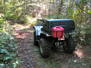
Last week, Wayne and I wanted to take a “wimpy” quad ride all on our own. We call a short (time and distance) ride a wimpy ride. Even though we’ve had our quads for several years, we aren’t that familiar with the trails around Powell River. We’ve been cautious about heading out on our own, but now we have two tools that give us more confidence. One is a great map book written by Dave, the president of the Powell River ATV Club. It’s called the ATV Trail Guide and costs $25. If want a copy, you can contact Dave through the ATV/BC website. All profits support trail maintenance and building activities.

The other item is a Garmin Oregon 300 GPS. We went to visit George (Mr. GPS) at Marine Traders. He’s a Garmin expert and can help you find the right model for your needs. We purchased the topographical maps on a card and the City Navigator North America road maps on a CD. That way we got the software to save and manage routes and waypoints. The Oregon 300 works with both Mac and PCs. Since we use Macs that was very important for us.

We parked our truck in town near Edgehill School at the top of Abbotsford Street. This is where the Wednesday trail group often starts their rides. We never guessed how beautiful the trail through the forest from this non-descript parking spot would be. Tall evergreen trees provided lots of shade for the lush fern and salal ground cover. There are many interconnecting trails in the area, so we used both map and GPS to stay on course. Along the way there was active logging, so we were watchful for trucks and other big equipment once we got to the logging road section.

Where the Edgehill Trail System meets Duck Lake Forest Service Road (FSR), we entered the Washout Trail. It’s well marked with a cement sign. This trail follows an old railroad grade used by trains hauling timber for the Hasting Timber Company in the early 1900’s. High winds and forest fires in the 1920’s caused damage that can still be seen in the understory today. The trail is easy to moderate, with a few protruding roots to negotiate.

From the Washout Trail we took Fred’s Trail down to Hammil Lake. Again, it is well marked with a wooden sign attached to a tree, but you have to watch for it. Fred’s Trail is narrow in places with larger roots to negotiate, but it is still in the easy to moderate category. Just after we entered the trail, we came to a bridge constructed by ATV riders over a fish-bearing stream. This is an example of how riders in the area respect and help preserve the environment. After our long, hot summer, there was no water left in the stream. We continued on Fred’s Trail to the Hammil Lake trail and followed it a short ways down to the lakeshore. Today the weather was cool and breezy, se we skipped a swim. Wayne tried a few casts while I had a pop and cookie break.

We decided to retrace our steps back to the Washout Trail. We turned right and followed the rest of the trail to its junction with Duck Lake FSR. A left turn took us to the Duck Lake Bridge. We stopped along the popular little lake for Wayne to try a few more casts. I guess today just wasn’t our day to catch any fish. Just a few klicks down Duck Lake FSR took us back to the Edgehill Tail System and our route back to the truck. Except for the short stretch on Duck Lake Road, the trails were all remote and beautiful. We are so lucky here in Powell River to have all of this literally right at our doorstep. -- Margy

Saturday, September 05, 2009

Girls Day Out

My mom is visiting me in Powell River this month. When the weather is nice, she comes up to the cabin, along with her (our) cat Stick Tail. They both enjoy getting out in the fresh air and sunshine. But when the weather is a bit cool or rainy, she and the cat enjoy the pleasures of our condo in town. I come down the lake every few days to check on how things are going and to have a girls day out.

We usually go shopping for groceries or just browse through the Economy Shop thrift store. Mom loves a bargain as much as I do. After we've "saved" lots of money by making our purchases there, we splurge on going out to lunch. Last week we went to the Savoury Bight Seaside Restaurant at the Beach Gardens Hotel just south of town.

Mom isn't a big eater, so we usually share a sandwich. They were very gracious about it, and even served our meal on separate plates (at no extra charge). The Savoury Bight is on the ocean side of the hotel with a view of the marina and the Malaspina Strait beyond. It's a great place to come on a sunny day so you can sit outdoors on their patio. If you come at sunset, you get a wonderful view with Texada and Harwood Islands in the foreground and the colourful sky reflected in the sea. The pub side also serves meals and drinks in an informal atmosphere.

It never ceases to amaze me how many great restaurants there are in Powell River. Maybe having a joint high school/college culinary arts program in town helps. Whatever the case, come have a taste of Powell River. It's a savoury place to live. -- Margy

Friday, September 04, 2009

Sunset at the Head

I shared about our boat trip to the head of Powell Lake last weekend. We anchored on the east shore so that we could get the last of the sun's rays.

We also got some colourful skies and reflections.

When you live in a place like this, who needs a vacation. -- Margy

Thursday, September 03, 2009

Snakes, Frogs and Polliwogs

This summer we've seen lots of polliwogs, big polliwogs, in the water around our cabin. These are not your normal, run of the mill polliwogs. These are mega-polliwogs that will grow up to be bullfrogs. Bullfrogs are not native in Powell Lake. They were imported to BC years ago by someone who thought it would be a good idea to "farm" them for their tasty legs. The farms didn't thrive, but the frogs did. Now they've spread across the Lower Mainland and the southeastern portion of Vancouver Island.

Bullfrogs may stay in the polliwog stage up to two years, feeding on algae and detritus in ponds and lakes. They can be seen swimming just under the surface, ruffling the surface much like a trout rising for it's evening meal. Right now there's an explosion of young frogs sitting on logs, rocks and our cabin floats. I know they are harmful to native frog species, but they are fun to watch. They seem to have no fear, staying put even when I walk nearby. But they better look out.

Right now we have lots of Common Garter Snakes hanging around. One of the top items on their menu is frogs. I wonder if there's a relationship here? Garter Snakes are excellent swimmers. They can negotiate a long stretch of water with just a few whips of their tails. And quick enough to overtake an unsuspecting frog, at least a young one. The BC Ministry of Environment website notes that the tables can be turned when it comes to larger bullfrogs. Garter Snakes have been found in their stomach contents. I guess turnabout is fair play as they say. -- Margy